Coastal Adaptation Measures in the Aquitaine Region of Southern France
Dipika Popatlal
Introduction
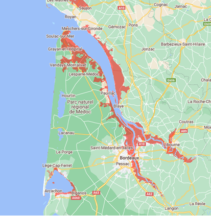
This commentary will focus on the Aquitaine region in Southern France. Specifically, what can be done to mitigate the losses from climate change and if there are any risks and benefits to this process. The Aquitaine region is most widely affected by erosion and coastal flooding risks, with the coastline already showing signs of retreatment (Baills et al., 2020). Rising sea levels would widen the Gironde Estuary. Bordeaux, with a 262,000 population, will be dramatically affected as there will be a loss of land. Libourne will also be affected as the Dordogne and Garonne riverbeds expand. The Arcachon Bay area will be flooded. Figure 1 illustrates these impacts on the coastal region.
Adapting to Coastal Hazards Caused by Climate Change

This commentary will explore two potential strategies that aim to adapt to the impacts of climate change, with a specific focus on coastal hazards. The first option involves the observation and study of natural evolution, while the second option involves actively controlling and directing natural processes. Both measures are necessary to address changes in sea levels (Smit & Wandel, 2006).
Monitoring natural processes entails observing areas devoid of human intervention to comprehend erosion and flooding. This involves utilizing coastal monitoring tools to collect data on physical processes, aiding in the anticipation of future alterations and potential adjustments in management strategies. Managing natural processes is crucial for mitigating erosion in coastal ecosystems, including dunes, marshes, and cliffs. For example, on the sandy coast of Aquitaine, this could entail practices such as vegetation planting or employing ecological techniques to stabilize sand and mitigate wind erosion (Baills et al., 2020). Nevertheless, implementing measures may also yield adverse consequences. An example commonly involves a defensive structure situated along the shoreline. The main objective of this structure is to reduce coastal flooding and prevent erosion along the coastline. However, it unintentionally causes increased erosion at both ends and the base of the structure (Baills et al., 2020).
Overall, numerous options for adapting in the near and moderate future (2030–2050 and 2080–2100) can be implemented. Emphasis should be given to proactive planning for adaptation, especially when there is a time lag between implementing a measure and seeing its anticipated advantages. This method emphasizes finding solutions (adaptation measures), which simplifies decision-making amid unpredictable changes in risks (Berrang-Ford et al., 2011). Table 1 summarises the impacts.
Table 1: Impact From Sea Level Rising & Measures
| Skip Table 1 | ||||
| Aspect | Details | |||
|---|---|---|---|---|
| Location | Bordeaux area, including the Gironde Estuary, Libourne, and Arcachon Bay, France. | |||
| Climate change impacts |
|
|||
| Adaptation strategies | Focus on flood defenses, land use management, and ecological restoration to protect against increased water flow and sea levels. | |||
| Coastal and river management approaches |
|
|||
| Risks of intervention | Infrastructure may impact ecology; protective measures could shift flood risks. | |||
| Community and stakeholder involvement | Collaboration among governments, communities, and organizations for effective adaptation. | |||
| Conclusion | The Bordeaux area requires integrated strategies for climate change adaptation, emphasizing structural, ecological, and community approaches. | |||
Note. Data from Baills et al. (2020), Berrang-Ford et al. (2011), and Smit & Wandel (2006).
Conclusion
In conclusion, whichever method to use will highly depend on how climate change has affected this area. In this area of France, the development of these adaptation pathways needs to be based on detailed hazard projections to maintain the life expectancy of these measures.
Media Attribution
Figure 1: “Land projected to be below annual flood level in 2100” [generated by Coastal Risk Screening Tool: Land Projected to be Below Annual Flood Level in 2100] by Climate Central (n.d.) is used under the Climate Central Terms of Use.
References
Berrang-Ford, L., Ford, J. D., & Paterson, J. (2011). Are we adapting to climate change? Global Environmental Change, 21(1), 25–33. https://doi.org/10.1016/j.gloenvcha.2010.09.012.
Baills, A., Garcin, M., & Bulteau, T. (2020). Assessment of selected climate change adaptation measures for coastal areas. Ocean & Coastal Management, 185, Article 105059. https://doi.org/10.1016/j.ocecoaman.2019.105059.
Climate Central. (n.d.). Land projected to be below annual flood level in 2100 [Map]. https://coastal.climatecentral.org/map/9/-0.512/45.1996/?theme=sea_level_rise&map_type=year&basemap=roadmap&contiguous=true&elevation_model=best_available&forecast_year=2100&pathway=ssp3rcp70&percentile=p50&refresh=true&return_level=return_level_1&rl_model=coast_rp&slr_model=ipcc_2021_med.
Smit, B., & Wandel, J. (2006). Adaptation, adaptive capacity and vulnerability. Global Environmental Change, 16(3), 282–292. https://doi.org/10.1016/j.gloenvcha.2006.03.008.

